Why not take a summer road-trip along the Columbia River Gorge, on Highway 84? Below are several stops literally just minutes from the highway.
------------------------------------------------------------------------------------------------------------------------------------
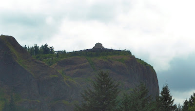
In Portland, take exit 22 to follow the sharp winding road to Crown Point. For the view from below, use exit 25 for Rooster Rock State Park. It is quite windy on this bluff, which also gives the advantage of being able to see a lot of fun river activities from above, including kite surfing and boating. http://www.oregonstateparks.org/park_150.php
Exit 31 (on the left) will lead you to Multnomah Falls, with a tunnel under the interstate. There is a shallow pool to cool your toes, or head straight up along the path to get to the bridge above the lower falls. There are LOTS of tourists here, so stay close to your group! http://en.wikipedia.org/wiki/Multnomah_Falls
Exit 40 will take you to the Bonneville Hatchery, to see the large-scale production of keeping Oregon lakes and rivers stocked with various species of fish. This area shows just how much effort goes into keeping Oregon rivers and lakes stocked with fish. http://www.dfw.state.or.us/resources/visitors/bonneville_hatchery.asp
Exit 44 puts you onto The Bridge of the Gods, which has great historical importance to local Indians, and many vendors are drawn here to sell their goods to tourists driving through. You’ll find lots of local produce, jerky, and fresh-caught fish. http://www.portofcascadelocks.org/bridge.htm
Exit 104, and following signs North across the Columbia River into Washington, will lead you to the WWI Veteran’s Memorial. This was built in 1930 to resemble Stonehenge as it was originally built. It honors servicemen from the local area, that died during that war. http://www.legendsofamerica.com/wa-stonehenge.html
Exit 109 provides a view of the John Day Dam. Lewis and Clark were fascinated by this location, before the dam existed. At the time of it’s construction, it was the second largest dam in the world. It has a small, and unfortunately poorly-kept, rest stop. The view is great, but definitely pass on the expired porta-potties. http://columbiariverimages.com/Regions/Places/john_day_dam.html
Exit 137 is a scenic pullout with a great view of the Columbia River Gorge, and the Shepherds Flat Wind Farm, which is still under construction. The city of Arlington, Oregon may only have just over 500 inhabitants, but it also maintains a waste management facility for all trash from Seattle, Washington, and some from the Portland area. The wind farm is a fascination for many, and puts the strong Gorge winds to good use. It is also probably because this wind flow, that the landfill doesn’t overpower the atmosphere. That is quite a bit of garbage!
http://en.wikipedia.org/wiki/Shepherds_Flat_Wind_Farm http://en.wikipedia.org/wiki/Arlington,_Oregon
Exit 188 is about 23 miles East of Boardman, Oregon, which is where I-84 begins to turn South from the Columbia River. Following this exit South (take a right from the exit), to the town of Echo (2000 census population 650, and .6 square mile total area). This was one of the main thoroughfares along the Oregon Trail from as early as 1851. Fort Henrietta Park is a National Historical Oregon Trail site, including a covered wagon outdoor exhibit, and antique fire equipment. http://www.echo-oregon.com/
I-84 turns South, heading for the Oregon-Idaho border, and the views turn into rolling hills, grassland, and mountain passes. Make sure you fill up on snacks and fuel when you have the option, because for much of the remainder of the trip, there isn't much of anything, aside from wide open spaces for miles.


